Monday, May 30, 2011

Mono Lake and Bristlecone Pines

how does one get down the bristelcone pines?

On a 3 day weekend Scott "B-Ratiuk" Batiuk, Scott Massed, and I decided to travel to Mono Lake and Bristlecone Pines. I studied Mono Lake in my Environmental Systems course at UWGB so it was  pretty sweet to see it in person.
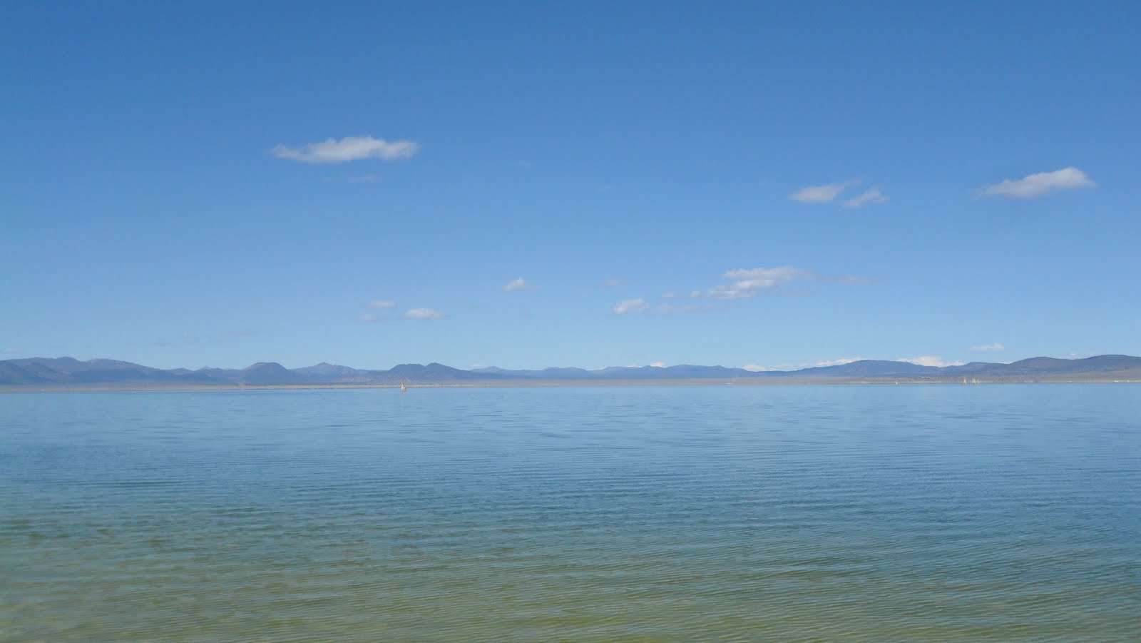
Mono Lake


Before diversion, the water was up to where I took this photo
Mono Lake is a very important and fragile ecosystem located in California, 2hrs south of Carson City, NV. The lake itself is 3x salter than the ocean and is home to very unique organisms and multiple populations of birds. Birds take advantage of the lake as a resting, feasting, and nesting area. They eat the brine shrimp and water flies which are the only organisms beside bacteria living in Mono Lake. Speaking of bacteria, the only arsenic based species is found in Mono Lake (http://science.nasa.gov/science-news/science-at-nasa/2010/02dec_monolake/). Concern for Mono Lake arose once the effects of diverting the lake's only stream inputs could be seen. Los Angeles claimed the streams around Mono Lake in the early 40s or 50s and therefore diverted them into their city causing a drastic decrease of water levels in Mono Lake. By 1962 the effects could be seen. The diversion of streams and rivers created a land bridge between an island in the lake and the shore. This land bridge allowed predators such as coyotes to prey on the nesting birds and their young. A few other consequences were the increase of salinity of the lake which could have caused brine shrimp and water flies to disappear thus crushing the ecosystem and exposure of limestone structures called tufas. Thankfully, environmentalist groups took action and the streams were diverted back to Mono Lake and water elevation is increasing again. In short, it is a truly amazing place that can be visited within a day and is a must if you are traveling in California.
B-ratiuk being B-ratiuk 
Mono Lake

Exposed limestone tufas


Enjoying the view

Panorama of Mono Lake. Photo by Scott Massed
Hot Creek Gorge and Camping

After Mono Lake, we went on a search to find a campsite. We took a detour to try and find some hot springs  we could enjoy. We failed, but in failing we found an awesome area called Hot Creek Gorge. I do not know much about Hot Creek Gorge besides it has pretty good trout fishing and it is too hot to go swimming in some areas. Since I do not know much about it, I will show it off in photos.


After the nice detour, we continued our adventure for a campsite. We ended up finding an area in the Inyo National Forest. It was pretty awesome. We were surrounded by Jeffrey Pines, had a view of the Sierras, and found an area away from the fisherman. It turned out to be a fantastic night. We enjoyed our wines and had some great conversations. We also managed to have some hatchet throwing contests.

our campsite

Monkey Bay. A wine from New Zealand.

Scott M. and his injured thumb


nice toss B-ratiuk!
Nighttime shot. Photo by Scott Massed.
Bristlecone Pines


After camping we headed to the Bristlecone Pines in the White Mts. On our way, we stopped in Bishop at Erick Schat's bakery for breakfast. If you are ever traveling through Bishop this place is a must to stop at. The food is excellent and you can get delicious bread for very cheap. Anyways, as I was saying, the Bristlecone Pines are located at the top of the White Mts. What is so significant about these pines? Well, they are over 4,000years old, thus making them the oldest living organism on the planet. Pretty fricken neat if you ask me. Even though they are the oldest living organism they are still very short (compared to other old trees like the Redwoods). Their habitat of cold temperatures, high winds, dry soils, and short growing seasons cause them to grow slowly. The wood of bristlecone pine is very dense allowing them to withstand bugs, fungi, and other pests. The oldest living tree is called Methuselah (4,789 from a core sample in 1957). The oldest dead tree, Prometheus, is recorded to be 4,844 years old, but was cut down for research. To help ease the hatred to the guy who cut down Prometheus, he did not know its age at the time.
Bristlecone Pine (Pinus longaeva)

Our main objective was to hike into the Methuselah grove, but time limits seem to be our enemy. Also, the damn snow. The snow covered many areas of the trail so we ended up bushwhacking (walking off-trail) our way around the park. In the beginning, bushwhacking was difficult because we had to hike vertically. Eventually we made it to the ridge and walked about until we decided to go back down and head up another ridge. During our walk we some spectacular trees. The elements have shaped them into incredible pieces of art. The exposed wood made some amazing patterns that my photographic capabilities could not capture. We are excited to go back in summer and make it to the Methuselah grove and spend more time bushwhacking this marvelous area. A definite must see in eastern CA.

The cones of Bristlecone.


The surveyors deciding where to go.

We made it to the other ridge in the background. 


Taking a nap.


We took a nap on the benches because it was so peaceful.


Our view as we were walking back.


Sunday, May 8, 2011

Pine Nut Mountains (Williams Combleaf surveying)


Williams Combleaf (Polyctenium williamsiae)

The purpose of our first visit to the Pine Nut Mountains was to do an intensive survey of the endangered species Polyctenium williamsiae commonly known as Williams Combleaf. Williams Combleaf is only found in two counties of California and a few counties of Nevada. It has been reported in Oregon but it is unknown if these populations still exist. In Nevada, Williams Combleaf is fully protected meaning it may not be collected or destroyed without the permission of the state forester fire-warden. Being fully protected also protects the destruction of the said species habitat. The main objective of our survey was to get the total number of individuals at two locations and GPS their total area. The information gained is going to be used for fencing in its habitat to allow ranching to continue to occur on the BLM land. Other objectives for our survey were updating other species in the habitat, invasive species survey, photo plots (helps to determine the habitat change and/or the change in species abundance) and plant collection. 

What to say about the Pine Nut Mts? Well they are beautiful but getting around in a truck is horrible. For now, it is the bumpiest road I have ever been on. Apparently, there are worse we will travel and the Pine Nuts are considered a medium rocky road. O man, I wish I would've taken a video of us driving. Next time I will. The first day was the worst. In total, we spent 7hrs driving to the first site and then to our campsite. It was brutal day of driving, but the work was worth it. When we got to our campsite we were greeted by cattle. Some of us spent the night in a trench to block the wind, in truck bed, or on the ground next to the truck. As for me, I slept in the truck cab. I guess during the night one of the interns (Bonnie) almost got run over by a cow.  That would have been a bad wake up call. 

After we woke, we traveled to our next site which was only a 30-45min drive away. We then hiked about 1.5miles from the road to site 2. There we set up the boarder for a fence-line so the archeologist who would be joining us could determine if it would impede on any cultural sites. Most of the interns, including I, got done rather fast with our work so we headed off to the "3rd" site which was nearby. I have the site in quotations because the BLM has never found any Williams Combleaf there but it is suitable habitat so each survey we have to look. Scott M. was also on a mission to find an arrowhead. Of course, we did not find any Williams Combleaf but Scott B. found a spearhead! We also got stared down by a wild horse which was kind of intimidating since they have tendency to charge.


Overall, the surveys were a success and we gained excellent experience on plant surveys, cultural artifacts, GPSing, plant collection, and the area itself.  
Site 1

Overview of Site 3


So pretty.

The spearhead that Scott B. found.


Doing the photo plot.

Random cool looking flower. I have no idea what it is.


Pinus monophylla


Donald Duck showing off some baby sagebrushes. 


Monday, May 2, 2011

Sand Mountain

Sand Mountain from the back.
The days of April 11th and 12th we spent at Sand Mountain, Nevada. Sand Mountain is roughly 2hrs northeast from Carson City and is located 15miles outside Fallon, NV. Sand Mountain is a sand dune nestled between rolling hills and just off the coast of a large salt lake. The dune itself is two miles long and 600 feet high. Sand Mountain was formed by sediment of neighboring (by neighboring i mean 2hrs south) Walker Lake. The winds carried the particles over the Stillwater Mountains and deposited them in front of the rolling hills that lay behind Sand Mountain. Sand Mountain is also considered a "singing" dune. On high wind days you can hear the particles moving across the dune. Today, it is very hard to hear the awesome singing because of all the Off-highway vehicle use. However, if you climb to the top and push down hard enough you can generate some of the singing.


Sand Mountain Blue Butterfly
Sand Mountain has a very delicate ecosystem. The delicate ecosystem occurs from the harsh environment and ever-changing sand patterns. At the moment, the main ecological concern at Sand Mountain is the endangered Sand Mountain Blue Butterfly (Euphilotes pallescens arenamontana). Sand Mountain is the only place in the world where the Sand Mountain Blue Butterfly occurs and its habitat is being slowly destroyed. The main factor for habitat destruction is the increasing popularity of the use of OHVs (Off-highway vehicles) at Sand Mountain. OHV use at Sand Mountain generates a lot of revenue for the local area and the BLM so it is very difficult to manage. The BLM Stillwater Field Office manages Sand Mountain. They have to figure out the best way to manage the ecosystem and still please the OHV users, environment groups, and themselves. They have developed certain trails for the OHV vehicles that do not cause too much habitat fragmentation. For now, these designated trails or voluntary but both the OHV and environmental groups know if they are not followed the trails will become enforced and tickets will be issued. The voluntary system started slow but has now picked up. However, it still is not at the point where the BLM would like. 


Kearney Buckwheat at bud break.
So where does our team of Botany interns come in? For the most part, we are responsible for habitat restoration and monitoring during events. On April 11th us, the recreation interns, and the UNR greenhouse director planted an area with Kearney Buckwheat (Eriogonum nummulare). Kearney Buckwheat is the only plant that the Sand Mountain Blue Butterfly eats as a larvae and as an adult. Its existence is solely dependent on Kearney Buckwheat. We planted roughly 250 plants. After the planting we had ATV training and camped out.


Us planting the Kearney Buckwheat seedlings.


ATV training is awesome. The purpose of our training was to get comfortable with driving on sand and get a lay of the land. We were going to be without our supervisor the next day so we had to do the training the night before, which I was not mad about. On April 12th we did surveying and GPS mapping of the plant Common Sandlilly. We are curious to see what dune peaks they were on and how low in elevation they would go. We counted each individual and GPS their location. The pictures below are from Scott Massed, my roommate and co-worker. You can follow him at scottmassed.blogspot.com


Other than Dean, Scott was the only one to get his ATV up the hill. We were relieved to not have to push it up.


Us on top of the main sand dune.

A nighttime shot by S. Massed 

On the ridge of the main sand dune. 

Sand Mountain (600ft).

Panorama of Sand Mountain's backside.


Talking about Kearney Buckwheat.

Donald Duck showing off his Common Sandlily